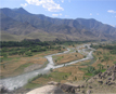
Dawlat Shah District is located 74 km from Mehterlam, the provincial centre. It is a mountainous district and borders Nuristan to the north, Tagab to the west and Panjshir to the north west. It has 60 villages. The main source of potable and irrigation water in the district is a river which runs through the district from the Farashghan mountains. Communications are poor, and there is just one main road which runs to the district centre.
The community has nevertheless themselves started to construct a road to Farashghan village, and has already completed 20km. They have now sought assistance from WFP for a food for work programme to help them to complete the project. In general, however, there has been little activity by humanitarian agencies in this district.
The majority of the population is very poor. It was reported that due to lack of work most young men are without occupations and many are armed and become involved in criminal activities. Nevertheless, it was reported that
Dawlat Shah is has good natural resources, such as forests, fruit and water.
Around half of the returnee families are currently rebuilding their homes.The others are either living in partially destroyed shelters or are staying with relatives.
The houses are built in the traditional mountain style - with stones and wood. Some villages were burnt during the Russian war particularly in (Khas Dawlat Shah village, Kalando and Atto) and the rest were destroyed during ombardment by the Russians. Despite this, the district has a good supply of construction materials (wood, stones and clay) and many succeeded in rebuilding their homes.
Good quality potable water is available only from springs, however not all inhabitants of the district have access to these and many use river water, which is not hygienic and causes water-borne diseases. For example, it
was reported that in late 2001 / early 2002 cholera killed 13 inhabitants of
Atto and Chekla villages. Water is carried long distances by women and girls.
Spring water is also not a reliable source as the springs are affected by
drought.
As this is a mountainous area, there is little arable land. What there is frequently damaged by flood (for example, in Karakchandal and Mora villages).
Due to the altitude of the land in many places it is not possible to irrigate it fromthe river. In the past spring water was used for irrigation but this is seasonal. A key source of income is forestry, howver much of the forest was cut down to provide wood for shelter re-construction. Some dry fruit trees were also burnt down during the Russian war.
It was observed that women were used in place of animals in this district to carry out heavy labour, including carrying wood from the mountains, farming, bringing water and other domestic and agricultural activities.