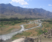
Alishing District is located 21 km from Mehterlam, the provincial centre, and borders Kabul Province. It has 12 zones, each with around 12 to 14 villages located in the valleys and mountains. The Alishing river crosses the district and is the main source of irrigation. It is a mountainous district, and many villages are extremely isolated.
The economy of the district is poor. Security in the district is reportedly good during the day, but there are some reports of robberies at night.
There is not much agricultural land because Alishing is a mountainous
district. Some rainfed land is cultivated in the hills, however during the dry season these fields are left fallow. Arable land in the plains is irrigated by river and by intakes (which are frequently damaged by flood). Elders stated that there was a need for reconstruction of intakes and protective walls, and also for a free / low-cost vetinary clinic, as there is a high level of animal husbandry. They requested water pumps for irrigation in three locations (Meal, Gona Pal, Saigal) as irrigation here is seasonal, and also expressed a need for fertilizer, proved seeds and tractors for agriculture.
The ethnic breakdown of the district is 60% Pashai, 25% Pashtun, 15% Tajik.
Relations between the three groups are reportedly good.