Alingar District is located 27 km from Mehtarlam, the provincial capital. It has around 60 villages located in fourmain valleys.
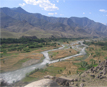
The Alingar river crosses the district and is the main source of irrigation. The security situation is reported to be relatively stable, although there are some private disputes.
Main crops are Wheat, rice, corn, vegetables and poppy.The district is mountainous, hence there is little arable land. Some of the agricultural land has been destroyed by flooding. There is a need for protective walls and repairs to irrigation intakes. Farmers also stated that they needed pesticides, proved seeds and fertilizer.
Main sources of income are Farming, daily wage labour and remittances from abroad.
It was reported that around 30% of the population work in agriculture, 20% work abroad in Pakistan and Iran, 2% are government employees, 2% traders, and around 45% are without work, the elders stated that as a result they become involved with armed groups and that this causes security problems. Many women work in the fields or carry wood long distances on their backs to sell to traders.
Those who immigrated to Pakistan now are returning to their home town. The returnees are increasing day by day.